
The last full week of January began on a wintry note when a winter storm blanketed part of the inner Northeast with snow disrupting travel and causing disruption to daily activities. Another snowstorm will be hot on the heels of early week’s system, forecasters at AccuWeather say, and the cold air left in its wake by the first storm could allow the second to dump heavier accumulations and pack a bigger punch.
The second winter storm intensified in the southwestern United States on Monday and will bring snow from New Mexico and Texas to Missouri through Tuesday. As the storm continues to move northeast, snow will arrive in the Ohio Valley by Tuesday night and eventually the Northeast by Wednesday.
Not only will there be colder air as the storm moves from Chicago and Detroit to Syracuse and Albany, New York, allowing snow to accumulate faster, but the colder air will remain in place throughout the storm’s duration , meaning precipitation will remain snow throughout the storm.
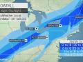
A broad swath of 3 to 6 inches of snow is expected from southern Missouri, Indiana, Ohio and southern Michigan to Pennsylvania and New York to Maine. The heaviest snowfall will pile up from upstate New York into inner parts of Maine, where a foot or more will accumulate. The 24-inch AccuWeather Local StormMax™ could fall into this zone.
Midwestern areas can expect snow-covered roads before the sun rises Wednesday morning. Travel conditions will worsen on portions of Interstates 70, 80 and 90 throughout Wednesday. Forecasters say motorists should be prepared for slick spots and slow driving.
Milder air will arrive closer to the Atlantic Seaboard, causing snow or a wintry mix to turn to rain — or all rain south of Boston.
 |
While some snowflakes are expected to fly across New York City on Wednesday morning, warmer air flowing north along the East Coast will turn the snow to rain. If this transition occurs early enough, the city can once again weather another storm without snow accumulating.
In the Big Apple, the longest streak of days without 0.1 inch of snow or more was 332, a streak that ended December 15, 2020. As of Sunday, January 22, the city had gone 319 days without any measurable snowfall. there the third longest snow drought of all time.
 |
|
Consecutive days without measurable snow in New York City as of January 22, 2023. |
AccuWeather forecasters say it seems likely that the milder air flowing to the northeast during the storm could cause the precipitation to turn into a wintry mix, and rain in many other locations as well.
From Philadelphia southwest to Washington, DC, there could be a slight push to confine winter rainfall concerns to the northern and western suburbs while cities receive rain.
Cold air associated with the storm is expected to pour into the I-95 corridor by Thursday. By that time, however, the storm and most of its precipitation will likely shift across northern New England, minimizing the chance of snowflakes. During the day on Thursday, the most difficult travel will likely be limited to northern New York, Vermont, New Hampshire and Maine, including portions of Interstates 87, 89, 91 and 93.
 |
Even with the heaviest snow in New England, Thursday’s storm will continue to be strong farther west.
Gusty winds following the storm will continue to sweep across the Great Lakes and linger snow showers from Michigan and northern Indiana to the Appalachian mountains of West Virginia, Pennsylvania and New York. In most locations, further significant accumulation is not likely, although areas immediately downwind of Lake Michigan, Lake Erie and Lake Superior could get fresh snowpack and some new slippery patches.
The cold air left behind by this midweek storm could open the door to more snow opportunities in the final days of January.
Do you want the highest level of security without ads? Unlock advanced, hyper-local severe weather alerts when you subscribe to Premium+ in the AccuWeather app. AccuWeather Alerts™ are triggered by our expert meteorologists who monitor and analyze dangerous weather hazards 24/7 to keep you and your family safer.
Comments are closed.